Category Archives: Historical Links, Pre-Independence

A devastating famine

famineBF08aug2014

Errant rainfall, lack of proper government policies and general ignorance resulted in the Great Famine of 1867-68. S Narendra Prasad looks back in time and deconstructs the misery and loss that affected a major part of South India.

The Great Famine of 1867-68 was a famine that befell many parts of southern and western India, before it spread to the north. Various reasons – social, economic, geographic and climatic have been attributed to the cause of this famine.

Two years prior to the first signs of famine in 1876, there was heavy rainfall in Bangalore and Kolar districts. This had destroyed ragi crops. The following year, there was only scanty rainfall and in some areas, it was much below the average rainfall due to which, by the end of 1875, most of the tanks had dried up. This highly affected the cultivation of paddy and other crops.

C B Saunders succeeded R A Dalyell as the Commissioner of India during the time. It was during the regime of Saunders, that the famine was tackled. Since the famine had occurred in most regions of the Deccan, it had severe repercussions at all levels, even in Mysore.
Loss in human population

In his address on October 7, 1881, in the Dasara Representative Assembly at Mysore, C Rangacharlu, the Dewan, put forth the losses incurred.

The address read as follows: “A general census was taken on the night of the February 17 under careful arrangements. The results which are being tabulated in great detail will furnish interesting statistics when completed. The population as returned by this census numbers 41,82,000 and shows a loss of 8,74,000 as compared with the census taken in 1871, but, allowing for the usual rate of increase in the intermediate good years, the loss of population by famine may be assumed to be fully a million or 20 per cent.”

Along with the loss in population, a great portion of livestock perished. Cattle, especially milching cows and bullocks starved to death due to lack of fodder. The procurement and marketing of crops declined and there was also a steep fall in the supply of food crops from neighbouring regions which were also famine-stricken.

According to statistics found in the government records during the fiscal years of 1874-75, Rs 109 lakh was collected as revenue. But during 1876-77, it stood at Rs 82 lakh and at Rs 69 lakh during 1877-78. And during 1880-81, it crossed the 10 million mark.

Relief measures
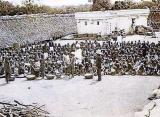
To tackle famine-related problems, the administration used all its machineries. For instance, it opened famine relief kitchens to feed people, whose numbers began to swell in towns, especially Bangalore.

The small town of Bangalore became a heaven for the huge influx of people who migrated for food and work from other parts of the state. These people were engaged in civil works and in turn were paid in grains. Around 20,000 migrants were employed for construction of the Bangalore-Mysore railway line.

The government gave its permission for grazing of cattles in forests, which resulted in a man-animal conflict. New tanks were constructed and renovation and repair of old tanks were also taken up in a war footing manner.

Large quantities of grains were imported from the neighbouring Madras Presidency. Separate officials were appointed to distribute the stock. Since the famine related conditions were same in major regions in the Deccan, the severity alarmed the officials in Calcutta. As a result of this, a separate Commissionerate with attached officials was created to supervise the famine relief works in Mysore.

The famine commissioner

The increase, both in the loss of human population and the death of livestock alarmed the government. Initially, Sir Richard Temple was sent as special Commissioner to begin the early relief works.
The visit of Lord Lytton to Mysore State in September 1878 resulted in the deputation of several experienced officials from other parts of British India. Hence came in Elliot who took over as Famine Commissioner. Surveyors, engineers and suboverseers were appointed to channelise famine relief work.
The statistics, related famine relief works and their outcomes are to be found in The Report on the History of Mysore Famine, 1876-1878. The report was submitted to the government. This report is considered to be of much historical value as it throws light on the different dimensions of the famine and its effects.
Likewise, the administrative reports published by the Government of Mysore annually starting from 1870 onwards are also extremely informative and valuable.

Consequences
The census figures in Mysore during later years showed an increase in population figures. The state incurred a debt of Rs 80 lakh. In Mysore, the famine severely retarded the agricultural process.
It reflected upon the gradual commercialisation of agriculture, increase in agriculture debt and the hand-to-mouth existence of nearly 40 per cent of the peasants in Mysore.

Inconsistency in the affairs of administration and in delayed tactics adopted to tackle the famine caused more concern. Added to this, the officialdom and the apathy of bureaucracy aggravated the situation.
But, looking at the second half of 19th century in India, many major famines have occurred after the 1860s. But Madras, Bombay, Mysore and Hyderabad regions which were affected by this great disaster had to wait for years to get over these setbacks and cope with the situation.

The Dewan in his speech in the 1881 Dasara Representative Assembly admitted, “As you are aware, the conditions of the Province has been very much affected by the great calamity which recently struck us. The ruinous effects of the famine are so fresh in your minds that I need not dwell on them.

It will suffice for me to say that it cost the state 160 lakhs of rupees. It also involved the government in a debt of Rs 80 lakh and withal deprived the province of a million of it. It also adversely affected the population and crippled its resources for years to come.”

source: http://www.deccanherald.com / Deccan Herald / Home> Supplements> Spectrum / S. Narendra Prasad / DHNS – August 05th, 2014

HISTORY OF WHITEFIELD – Once an Anglo-Indian village, now an upmarket suburb

Whitefield’s history dates back to 1882 when David Emmanuel Starkenburgh White decided to set up ‘a self sufficient Anglo-Indian village’. 

Whitefield – what kind of images would this name evoke? most likely IT – a glass and steel building, the Technology Park or maybe even the Sai Baba Ashram, anything but a village. Well, Whitefield or rather the old settlement of that name certainly qualifies as a village and a lost one at that.

I first visited the old settlement more than a year ago in connection with another research project and was fascinated by its circular planning and wished to know more about its history. My starting point was of course, Lewis Rice’s 1887 Mysore Gazette. In it he describes Whitefield as, ‘the principal of the Eurasian and Anglo-Indian settlements in the east of Bangalore taluq’, named after D S White…‘it is 2 miles south of the railway station of the same name and 12 miles east of Bangalore’. I pursued my interest a bit further and finally with the aid of Indian National Trust For Art and Cultural Heritage (INTACH) the first phase of my research into tracing the origin and evolution of the settlement is nearly complete.

The view of Whitefield from Kaolin Hill, with new high rise buildings in the distance./  Pic: Meera K
The view of Whitefield from Kaolin Hill, with new high rise buildings in the distance./ Pic: Meera K

Whitefield’s history goes back to 1882 when David Emmanuel Starkenburgh White decided to set up ‘a self sufficient Anglo-Indian village, one where everyone would work towards the common good and no man would own property. White, himself an Anglo-Indian, was founder and first president of the Anglo-Indian Association of Madras and instrumental in setting up the Coorg and Mysore branch. This branch petitioned the Government on behalf of the Association for land and was granted nearly 4000 acres of it by the Maharaja of Mysore on ‘very favourable terms’! White’s vision was that the settlers would take to agriculture and gradually develop into a community of self sustaining farmers.

Ten years after its establishment, the 1897 edition of the Gazette states that, ‘as of 1889 the settlement had 25 families of which 6 were non-resident, numbered 115 people in total, 12 cottages built on the village site and 14 farmhouses built on the surrounding land. It mentions ‘a Roman Catholic Chapel and parsonage, a Protestant Church and parsonage under construction, a school with 31 pupils with residence for the Head-master and wife, who assisted him in the teaching’.

So did the idea of a farming village succeed? There appears to have been doubts about this even way back then. At the least, did any physical remains of the village survive? Yes and no, but first, the route to get us to the place. When I visit the settlement, I prefer to drive past International Tech Park, Bangalore (ITPB), take a right turn at Hope Farm junction, go past the Coffee Day and turn right onto the road opposite the Reliance Fresh outlet and there you are! Why this route, well, the stretch from Hope Farm to the settlement was also the historical route when you could ‘arrange for a bullock cart or tonga for 8 annas to get you to the settlement from the railway station of the same name’. In the late 1800s you had to write to Rose White to make arrangements for the same but today I guess you can make it on your own steam.

Further, you would be following the footsteps of a number of historical visitors including Lord Connemara, who visited the place in 1890, when he was the Governor of Madras. It is written that he rode on horseback and stopped at the pass between Kaolin Hill on the right and Hamilton Hill on the left to get his first view of the settlement in the valley below. Kaolin Hill still survives as part of the Roman Catholic Church property, housing the Stations of the Cross, while its opposite number has been cut up for some development (probably apartments).

Inside the Memorial church, Whitefield.  / Pic: Meera K
Inside the Memorial church, Whitefield. / Pic: Meera K

Moving on, the road you turn onto abuts the Memorial Church property – the original Protestant Church, which is still pretty much as it was originally. The road leads to a central circular open area, currently sub-divided into a park and a playground. This central area was the original ‘village green’ with the village pond to one side, which was filled up sometime in the early 2000’s and replaced with a concrete ornamental fountain! Thus regularly flooding all the houses on the low lying side of the settlement, where earlier all the storm water was diverted into the pond in a planned manner. Margaret Lunel, a long time resident, remembers dangling her feet in the muddy water of the pond while sitting on a tree branch that spread right across it. The pond held other memories too and briefly the Memorial Church organ! But that’s another story.

J E Giddens, probably one of the oldest residents, who has been here since the 1930s, remembers that the central ‘village green’ was overgrown with lantanas and jackals and hyenas would roam through it, where kids now play cricket.

As you walk along the Inner Circle road you would be struck by the contrasting picture it presents. To one side most of the old bungalows have been knocked down, the plots sub-divided and apartment blocks towering well above the treeline have come up. While, further along the same stretch you could still imagine yourself in the past as tall mature trees continue to shade the avenue and the large plots with their bungalows set right back. These bungalows are generally characterised by their symmetry, a driveway leading to a covered porch, verandah and living areas beyond, all roofed with Mangalore tiles on timber trusses.

However, few of these bungalows remain and the ones that do have generally been altered one way or another. White, visiting today would not be able to recognise the place. In a little more than one hundred years his Utopia – a self sufficient village has transformed into an upmarket suburb of the city, one that generally does not recognise the existence of this unique enclave – the price of ill planned urbanisation. Thankfully, memories remain unaltered and some very long ones abound in the settlement, each linked to an interesting anecdote.

Paul D Souza, who lives in one of the few remaining bungalows, swears the tree stump in his garden was the one Winston Churchill used to tether his horse when he came to the Inn in Whitefield to court Rose Hamilton, the Inn Keeper’s daughter! (A telephone pole fell on the tree stump and brought it down. Paul rescued the stump from the Inn garden before it became firewood. The Inn still stands).

One of the residences, which was once Waverly Inn, where Winston Churchill stayed. . Pic: Meera K.

Further, close to the RC Church where now stand villas, once stood some rocks with the initials WC and RH carved within a heart! These rocks were blasted to make way for the villas.

Whether you believe these stories of the intangible heritage of Whitefield, the stories that are related by people with the ability to transport you back in time.

Development is inevitable especially in a locality like Whitefield with its present day ‘desirable tag’.  So should we be happy to just live with these memories or should we make some efforts to retain the last vestiges of tangible heritage as well?

However, as long as legislation does not exist to protect heritage, tangible or otherwise, coupled with present day demand for rapid urbanisation and lack of public cooperation, you will only be left with stories, which again will only remain as long as the story teller.

______________________________________________

Krupa Rajangam, Architect specialised in Heritage Conservation from the internationally reputed University of York, UK, principal ‘Saythu…linking people and places’. Krupa is interested in the adaptive re-use of places and makes time for her research interest in the role of community in conservation.
______________________________________________
www.bangalore.citizenmatters.in / Citizen Matters, Bangalore / Home> Features> Whitefield> /  by Krupa Rajangam / March 04th, 2010

SACRED TREES OF BANGALORE – Tradition helps protect sacred trees in old Bengaluru areas

Even in the highly commercialised old Pete area of Bangalore, there remain some pockets of greenery that provide some fresh air to the locality. How did they survive? Here’s a study that explores reasons.


A sacred fig tree used as a place of worship. Pic: currentconservation.org

It is a common sight to see a tree protruding onto a pavement, often onto the street and sometimes even acting as a divider in the centre of the road. These are trees that have survived the axe-happy city-planning authorities just by their nature of being classified culturally as Sacred Trees.

Divya Gopal, Harini Nagendra elaborate on the importance of these trees and the reasons they have survived the onslaught of development in the city, in an article, Sacred trees in the urban landscape of Bangalore, India, published in Current Conservation, Maria Tengö.

_______________________________________________

About the authors

Maria Tengö is a researcher at Stockholm Resilience Centre and co-theme leader of the Stewardship theme. Divya Gopal is a researcher at the Institute of Ecology, Technische Universität, Berlin. Harini Nagendra is Professor at School of Development, Azim Premji University, Bangalore.

_______________________________________________

Sacred trees include sacred fig or peepal (Ficus religiosa), neem tree (Azadirachta indica), coconut tree (Cocos nucifera), banyan (Ficus benghalensis), Indian blackberry (Syzygium cumini), banni (Prosopis cineraria) and bael (Aegle marmelos). These trees are found around temples, heritage sites or the Ashwath Kattes and often as a single tree or group of trees on roadsides and other areas.

Sacred figs are tall, with huge trunk areas and large canopies. One can see sacred figs growing even in crevices of buildings! They have many medicinal properties and are biodiversity hotspots nurturing insects, birds, squirrels, bats and monkeys.

__________________________________________________

What is Ashwatha Katte?
The Ashwath Katte is an area with a slightly raised platform, generally with sacred fig (Ficus religiosa) and neem tree (Azadirachta indica) planted together under which one often finds idols of serpent gods. Other sacred species, specifically the Ficus species, may also be found in a Katte.

 __________________________________________________

The authors had done a sample survey to map the tree cover of the Pete in Bengaluru – the quadrangle from Town Hall to Briand Square to Tank Bund Road to Avenue Road. Established in the 16th century, the Pete was the city centre and hub of commercial commercial activity that was interlaid with residential layouts. Today the Pete that has undergone several political, social, economic and geographic changes appears congested to us. However a small numbers of trees were found to be surviving – most of them sacred trees, predominantly sacred figs forming tiny islands of green!

Places of urban greenery remaining in old Bangalore Pete area. Pic: currentconservation.org

Slum settlements were other areas where there was a large presence of sacred trees, here the area around the trees were multifunctional in nature. In addition to being worshipped these were hotspots of social activities, livelihood activities like selling flowers and vegetables and the canopies were playgrounds for children.

The article also elaborates on the importance, biodiversity values, cultural and religious beliefs and medicinal values around the various sacred trees, that maybe the reason they have survived in the city. For example, peepal tree is a symbol of fertility among the majority of locals.

Clue for BBMP on greening the city?

As the city continues to lose its green cover and the authorities take up greening drives, wrong choices of trees are often made. However, sacred trees, heritage trees and other culturally protected trees have so far managed to resist the pressures of urbanisation.

As the authors point out, these examples can help BBMP learn how to design parks and green spaces that engage people in their protection and management – for a ‘green infrastructure’ of trees, parks, and other green spaces is required to sustain our well-being.

Cultural ecosystems across the world are some of the best-protected areas, securing biodiversity values as well as spiritual and other cultural values for humans. If we can recognise such values and practices that protect trees, we can better secure pockets of nature!

______________________________________________

Josephine Joseph researches and writes on urban governance, civic and environmental issues in Bangalore City, from a ‘citizen’ point of view.
_______________________________________________
www.bangalore.citizenmatters.in / Citizen Matters, Bangalore / Home> Environment> Trees> City News / by Josephine Joseph / August 04th, 2014

Bangalore’s rail connectivity turns 150 years

A front view of Bangalore City Railway Station some time before it was completed in April 1968.

It has been 150 years since Bangalore appeared on the railway map of India. It was on August 1, 1864 that Jolarpet was connected to Bangalore Cantonment.

According to information provided by South Western Railway, the first train journey in south India took place on May 28, 1856 from Royapuram to Wallajah Road. Eight years later, Madras Railway Company opened the Jolarpettai-Bangalore Cantonment branch line. The Madras-Bangalore Mail was launched the same year.

In 1862, the line reached Renigunta and then to Raichur in 1871.

The Yeshwanthpur-Doddaballapur Meter Gauge line was opened in 1892.

In 1944, the rail network was nationalised. On April 14, 1951, the three major networks administered by the erstwhile Madras and Southern Maratha Railway, the Southern Indian Railway and Mysore State Railway were joined to form Southern Railway.

Due to historical reasons, the headquarters of the erstwhile Mysore State Railway was located in Mysore though Bangalore was the hub of operations. To improve administration and enhance monitoring, Bangalore Division was inaugurated on July 27, 1981.

No rail museum

The city does not have a museum to showcase its rail journey. Till a few weeks ago, memorabilia was being exhibited on Platform One of Bangalore City Railway Station. At present, visitors can go to Platform Five where two galleries exhibit cartoons and paintings related to trains.

The galleries had no visitors on Friday. Staff in both galleries said that visitors show up only when trains are delayed.

source: http://www.thehindu.com / The Hindu / Home> News> Cities> Bangalore / by Renuka Phadnis / August 02nd, 2014

So few and far between

Tradition prevails: ‘Perfect Peace’, the home of Merlyn and son, Paul D’Souza, is located at Inner Circle, Whitefield. / Photo: K. Murali Kumar / The Hindu

The D’Souzas recall the days when Whitefield’s roadsides were venues for long conversations

Sipping a glass of Mango Fool in the tranquil company of squirrels and birds, in a house that dates back to the early 1900s, can give you a natural high. The house, ‘Perfect Peace’, owned by Merlyn D’Souza, is the quintessence of Inner Circle, Whitefield. It has withstood the test of time amid the onslaught of rapid commercialisation.

The Inner Circle is part of the Anglo-Indian settlement which was set up in 1882 on land granted by the Mysore maharaja. Remnants of the colonial era are reflected in the architectural style of the beautiful garden, high-tiled roof and wooden decor and the antique curios in the house (on cover). Merlyn’s son, Paul Gerard D’Souza, explains that very few houses in the area retain the charm and history of the bygone days.

Paul reminisced about the days when Whitefield was a small community of Anglo-Indians and a trunk call away from Bangalore. “Everybody knew each other in the community,” he recalls. “We often got together in the Whitefield Club and at the Memorial Church.” He fondly remembers the days when there was no traffic in Whitefield and the roadsides were perfect venues for long conversations. He recalls that the Whitefield Club, which was then an exclusive Anglo-Indian body, was a place where one could feel the richness of their culture. “Young and old, from toddlers to grannies, were called for parties and gatherings at the club. There was no age distinction. We always got together as a community,” he says.

With the advent of the IT industry in Bangalore, tech parks have spilled all over the town, changing not just the landscape of the area but also the lives of the old Anglo-Indian settlers. Paul lamented that the Anglo-Indian community in the neighbourhood is nearly nonexistent today. “Whitefield today is associated with the rich and the IT industry. A lot of land is being grabbed for big projects,” he rues. The Inner Circle today has very few houses owned by Anglo- Indians. As Paul says, “There is no other place like this in Bangalore, and I intend to preserve the perfect peace of the Inner Circle.”

source: http://www.thehindu.com / The Hindu / Home> News> Cities. Bangalore / by James Prashanth Lobo & Sandra Marina Fernandes / May 11th, 2011

Jayalalithaa & Vyjayanthimala : Right Royal Mysore connections

A vintage photograph showing Sandhya (middle row - third from left) at an event in Vanita Sadana, a women’s development institution in Mysore, contemporaneous with Mahila Samaja and Mahila Sadana.
A vintage photograph showing Sandhya (middle row – third from left) at an event in Vanita Sadana, a women’s development
institution in Mysore, contemporaneous with Mahila Samaja and Mahila Sadana.

Sir,

Readers of your curiosity-provoking news report on J. Jayalalithaa’s Mysore roots (SOM dated July 9) may find it interesting to know that her mother Sandhya was a socialite in Mysore, with links to the ruling elite. After leaving Mysore and living for a while in Bangalore, Sandhya settled in Madras and started acting in Tamil films at the instance of her actor-sister Ambujavalli (Vidyavathi).

Sandhya’s pre-screen name was Vedavalli (Vedavathi) and it is said that even Jayalalithaa’s original name was different: it was “Komalavalli.” It is also said that the prefix “Jaya” in the names of her family signifies their association with the Palace.

Jayalalithaa’s grandfather Dr. N. Rangachar, L.M. & S., was a Palace doctor in Mysore and his name is exclusively inscribed on a donation plaque in Mahila Samaja, close to Jayalalithaa’s ancestral residence on 2nd Main Road, Lakshmipuram (the building now houses the Lakshmipuram Sports Club). Dr. Rangachar’s image is also seen in an enchanting mural depicting a group of Durbaris at the Mysore Palace.

This context rekindles memories of the similar, interesting roots of Vyjayanthimala in Mysore. Her mother Vasundhara Devi, a glamorous dancer and Tamil film actress, too, enjoyed direct contacts with the Mysore Royalty. Vasundhara Devi counted the Yuvaraja of Mysore, Kanteerava Narasimharaja Wadiyar, among her admirers, and she and her family were part of the Yuvaraja’s contingent that toured Europe in 1939. Vyjayanthimala’s paternal grandfather Dhati Gopalacharya and step-grandmother M.D. Ranganayakamma founded Mahila Sadana on N.S. Road (near Maharani’s High School) in Mysore.

—S.G. Seetharam

on e-mail / Gita Road, Mysore / 17.7.2014

source: http://www.starofmysore.com / Star of Mysore / Home> Voice of the Reader / July 27th, 2014

Three Jaina temples at Halebid

Pages from History

JainaTemplesBF 01aug2014

by Prof. A.V. Narasimha Murthy

Hundreds of tourists visit the famous temples at Halebid which was also known as Dwarasamudra.It was their capital and when they changed the capital to Belur, this place became famous as old capital or Halebidu. Normally, tourists visit the famous Hoysalesvara temple here and enjoy the beauty of the delicate sculptures. Generally people do not even know the existence of three Jaina temples in the same place. Though these three Jaina temples do not exhibit that enchanting beauty of the Hoysalesvara temple, they present another facet of Hoysala art.

Many may wonder how Vishnuvardhana, a devoted Vaishnava was able to build these three temples in his capital Halebid. To understand this we have to just go back to some incidents that happened in the early life of Vishnuvardhana. His original name was Bittideva and was a staunch Jaina by religion. After coming into contact with the great Sri Vaishnava Saint Ramanujacharya, he became a Vaishnava and changed his name Bittideva to Vishnuvardhana. There are no historical records to support these incidents but these legends are very strong and make us believe them. One such legend states that Vishnuvardhana had a daughter by name Hariyaladevi and she was a problematic child physically and mentally from her birth itself. The physicians of the Palace could not cure her and make her normal. At that time Vishnuvardhana who had heard of Ramanujacharya paid a visit to him and narrated him the plight of his daughter. The saint by uttering some mantras cured the daughter of Vishnuvardhana and the latter was greatly imp

ressed by the spiritual power of Ramanujacharya and became his disciple and consequently he changed his name to Vishnuvardhana.

There is another slightly different legend to explain the name Vishnuvardhana. Bittideva had many wives among whom Lakshmidevi was the most beautiful and charming. She was a follower of Sri Ramanujacharya. She used her influence on her husband and converted him to Vaishnavism from Jainism. Naturally Bittideva changed his name also and began to be known as Vishnuvardhana. All these legends have no historical basis but they are strong in the minds of the people and the historians. Though Vishnuvardhana was a Jaina in the beginning and got converted to Vaishnavism, he was tolerant of Saivism which was one of the major sects of the period. This is evidenced by many Siva temples built by him.

The Jaina architecture is based upon Hindu architecture itself but the Jainas made some innovations and changes to suit the needs of their religion. They followed the usual pattern of Garbhagriha, Sukhanasi, Navaranga and Mandapa in a row. They added a pillar in front of the temple and it became unique as Manastambha. The Jaina art can be studied on dynastic pattern as Ganga, Chalukya, Hoysala, etc. That shows their inclination for adaptability. The double storeyed sanctum was an innovation of the Jains. But this did not become popular. The uniqueness of the Jaina sculptural style is the highly glossy polish of the Tirthankara images, even if the structure was built of granite. Another unique feature is the presence of tall metallic images found in many Jaina temples.

The three Jaina temples in a row at Halebid are dedicated to Parsvanatha (west), Adinatha (central) and Shantinatha (east) Tirthankaras. Parsvanatha was the 23rd Tirthankara (Jaina guru) and many people consider him as the real founder of Jainism. He was the son of Asvasena of Kashi. He lived as a housholder for 30 years and later became an ascetic. After deep meditation for 83 days, he attained the highest spiritual knowledge. He had a huge following of 1,64,000 men and 3,27,000 nuns who were highly devoted to him. He died at the age of 100 years on the summit of mountain Sammeta. Scholars have placed him in 8th century BC.

The temple dedicated to Parsvanatha was built by Bopparaja, the son of the famous Hoysala General Gangaraja. It was built in memory of Gangaraja. At this time the news of the victory (vijaya) over Bankapura was conveyed to Vishnuvardhana and he named the deity as Vijaya Parsvanatha. The temple is built of soapstone and consists of garbhagriha, sukhanasi and a navaranga and a detached enclosure. The square garbhagriha and the walls of the navaranga are decorated with pilasters at intervals. The most important attraction of this temple is the image of Vijaya Parsvanatha which is imposing by its height of 14 ft. The deity has a seven-hooded serpent over his head. The Tirthankara is a perfect yogi or a realised soul with sympathetic and benign smile on his lips. The lathe-turned elegant pillars in the navaranga are highly polished and exhibit mirror-like glossy surface.

The next temple is dedicated to Shantinatha. This is also similar to the first temple. It was built in 1192 AD during the reign of Ballala II (1173-1220). He was the next great king in Hoysala dynasty after Vishnuvardhana. He was born in 1154 AD and was appointed as a Yuvaraja as a child. He began taking interest in administration from his eleventh year. He was ruling for sometime with his mother Echaladevi and subsequently as an independent king. His father Narasimha was weak and was immersed in worldly pleasures. Ballala rebelled against him and after his father’s death, he assumed full powers and defeated many kings including Chalukya and Yadava kings. He was a patron of art and architecture also. He built this Jaina temple dedicated to Shantinatha. It consists of a garbhagriha, sukhanasi, navaranga and a mandapa. The first three parts were built during the Hoysala period while the mandapa was added during the Vijayanagara period. The sanctum has a fine image of standing Shantinatha which is 14ft in hei

ght. The navaranga pillars do not exhibit the glossy quality. Perhaps it was not finished at all.

The frontal mandapa contains granite pillars which are tall but are not artistic as those of the hoysala pillars. But they provide good support to the roof of the mandapa. Before the temple is a tall pillar referred to as manastambha which is similar to garudagamba or nandi kamba of vaishnava and saiva temples respectively. The manastamba is very elegant and indicates the special feature of jaina temple art, and can be seen in all Jaina temples. They can be seen in Sravanabelagola in plenty which is a great Jaina architectural centre not only in Karnataka but also in India.

Sravanabelagola is not only an ancient Jaina centre but also has a large number of Jaina monuments including temples and an evolution of Jaina architectural and sculptural art can be traced. Infact, its history starts from the Chandragupta basadi. The present structure is of a later period but scholars have opined that at that very spot existed the ancient Chandragupta basadi almost contemporary to the migration of King Chandragupta and the sage Bhadrabahu. Even at this great centre we do not come across three Jaina temples in a row close to each other. Thus it is unique feature here at Halebid.

The last temple is slightly smaller in dimension. It is dedicated to Tirthankara Adinatha. It was built in 1138 AD during the reign of Vishnuvardhana. He had a minister by name Mallayya and this temple is his initiative. An inscription is available and it records some historical details. Thus the three temples built by hoysala kings in their capital Halebid gives a hint to the importance given by them to jainism in addition to other religious of the State. This religious harmony of the hoysala period is specially noteworthy. This reminds us of a hoysala inscription which enunciates the equality of all Gods like Siva, Vishnu, Brahma, Budda, Jina, Karta etc. That this was not an empty boast and a lofty idea in theory but was practised in daily life is proved by the temples built by hoysala kings to all the religious faiths of their kingdom. That was the greatness of the hoysala dynasty.

source: http://www.starofmysore.com / Star of Mysore / Home> Feature Articles  / July 26th, 2014

Postal trainees explore the heritage of city on cycles

Dr. C.G. Betsurmath, Commissioner, Department of Archaeology, Museums and Heritage, is seen leading a team of postal trainees in front of Kote Anjaneya Swamy Temple during the Heritage Cycle Rally which began from Town Hall premises here yesterday morning.

Mysore:

The trainees of the Postal Training Centre (PTC), Mysore, explored the heritage of the city on cycles yesterday.

The cycle rally, organised by the Department of Archaeology, Museums and Heritage, was flagged off by Veena Kumari, Director of PTC from the Town Hall premises at 7 am. It was led by Dr. C.G. Betsurmath, Commissioner, Department of Archaeology, Museums and Heritage.

The participants covered Clock Tower, Chamaraja Circle, K.R. Circle, Lansdowne Building. Banumaiah’s College, Mysore City Corporation, Jaganmohan Palace, Parakala Mutt, Commercial Tax Office, Lokayukta Office, Oriental Research Institute, Crawford Hall, Maharaja’s College, Yuvaraja’s College, Maharani’s College, Metropole Hotel, Railway Station, Divisional Railway Office, K.R. Hospital, Govt. Ayurveda College, Central Library, Devaraja Market and the Dufferin Clock Tower on cycles.

Speaking on the occasion, Dr. Betsurmath said that yesterday’s rally was the second with the first being the rally conducted for the staff of Indian Overseas Bank.

He said that there were demands for such rallies from other institutions and offices and added that trainees of Administrative Training Institute (ATI) would participate in the next rally on Sunday.

Resource persons in the rally included retired professor of the Department of Ancient History, University of Mysore, Dr. N.S. Rangaraju, Deputy Director and Heritage In-charge Gavi Siddaiah, journalist Echanur Kumar and Curator in the Archaeology Department L.L. Gowda.

source: http://www.starofmysore.com / Star of Mysore / Home> General  News  / July 21st, 2014

Pages from History : A mosque and a tomb at Gulbarga

by Prof. A.V. Narasimha Murthy, former Head, Department of Ancient History & Anchaeology, University of Mysore

Gulbarga, which is now a district of Karnataka, had a chequered history from ancient times. It was the habitat of stoneage man as evidenced by the stone tools found in various sites. Sannati in this district was a flourishing Satavahana site as evidenced by parts of Buddhist stupas and Buddha images as discovered in archaeological excavation. Asokan inscription also has been found in Sannati. It has also yielded a large number of ancient coins.

The Rashtrakutas, who ruled over Deccan and made incursions even to north India, had their capital at Malkhed which was located in Sedam taluk of this district. Subsequently, it came under the rule of the Chalukyas of Kalyana. When Mohammad Bin Tughlaq invaded this part of Deccan, Gulbarga came under his rule.

It came to prominence when Alauddin Hasan Gangu Bahman Shah founded the Bahmani kingdom in 1347 AD. It became his capital and continued to be so under various kings of this dynasty. When Bahmani kingdom was divided into five States, some parts went to Adil Shahis of Bijapur and Barid Shahis of Bidar. During the Deccan invasion of Mughal emperor Aurangazeb, Gulbarga was included in his empire. After the death of Aurangazeb, the Asaf Jahi dynasty became prominent and it was included in it. It was included in the province of Nizam of Hyderabad.

In the meantime, the parts of this district came under different chiefs known as Nayakas. The district was included in the kingdoms of Surapura Nayakas. This hunter community chiefs of Surapura were very brave and under the leadership of Venkatappa Nayaka rebelled against the British and he was put to death and the latter took away his kingdom and handed it over to Nizam of Hyderabad.

The famous Salar Jung introduced many reforms and Gulbarga became a part of Surapura district. In 1873, Gulbarga was made into a separate district. In 1956, some taluks of this district were transferred to Andhra Pradesh and the remaining taluks formed parts of Gulbarga district and it was included in Mysore State, now Karnataka.

Gulbarga district has a respectable place in literary and cultural history also. The author of Kaviraja Marga belonged to this place, poet Ponna and Devara Dasimayya belong to the district. It is also considered to have had connections with poet Lakshmisha, saint Akshobhya Tirtha of Dvaita philosophy, Pushpadanta, the author of Mahapurana etc. Thus it had a glorious history and it became more famous because it became the capital of the Bahmanis in the medieval period, and for its Islamic buildings. Two such buildings are examined here:

Jamia Masjid (mosque) at Gulbarga is a unique mosque with a special feature not seen in other buildings of this type. Hence, it is famous all over the Islamic world. According to a Persian inscription, this mosque was completed in 1367 AD during the reign of Mahmad Shah Bahmani. He was the second Sultan of the Bahmani dynasty and he was successful in consolidating the political power of the Bahmani dynasty. He also introduced many administrative reforms and his period saw peace and prosperity. Architecture received great patronage during the period. This mosque was designed by an engineer- cum-artist from Persia, namely Rafi. He was a hereditary architect from the town of Kazvin in north Persia. The uniqueness of this mosque is that it has no open courtyard and the entire structure is covered. It is believed that this is not according to the Islamic tradition and hence people did not favour it and consequently this type of building was not repeated and for this reason this mosque became unique. The architect has designed it in such a subtle way as to show the harmonious blending of Persian and Indian elements in an undistinguishable way.

The mosque is built on a rectangular base of 216 ft in length and 176 ft in width. It has cloisters on its three sides. The other western side has a nave under a high dome. The entire area is filled by rows of aisles forming sixty-eight bays each having a cupola for its roof. In effect, the entire area is made into a vast closed pillared hall. The main dome which is an elegant structure and huge dominates the vicinity. The interior of the central dome is artistically ornamented with foliage designs. These attest to the long experience and superior technical knowledge of the artists. The decoration over the arches adds a grace to the entire building. The exterior walls have tall and slender arches repeated at regular intervals. This provides a graceful façade to the building on all the four sides.

Inscriptions in Persian at different places add a charm because of the fine calligraphic characters. With all these characters, the Jamia mosque is a unique monument. It has a dargah or tomb of saint Haji Hafeez Jamaluddin Ul Harmain. He was the grandson of Ghouse Azam Dastagir. He lived in Iraq. He was a famous philosopher and a learned man and was highly respected in the Islamic world for his knowledge and saintly living. Devotees go to this mosque to pay homage to this saint. Even today Jamia mosque attracts visitors in huge numbers.

Gulbarga has a large number of tombs of the rulers of the Bahmani dynasty and they are found in two groups. The first group consists of simple tombs beginning from the first ruler Alauddin Bahman Shah. The second group is more famous because of the architectural embellishments and innovations. As a group they are referred to as Haft Gumbaz or seven domes in local parlance. Actually it consists of the tombs of the four sultans beginning from Mujahid Bahmani who died in 1378 and of his successors. Firoze Bahman Shah (1397-1422) was a peace-loving sultan and sent an embassy to Timur in 1401 and thereby became the head of the Deccan, Malwa and Gujarat. He invited a large number of Arabs and Persians to his kingdom and this is reflected in the architecture of the period. This King died in 1422 and a tomb was built in the same year for him.

This tomb has many unique characters. It expresses the architectural features of Tughlaqs in addition to local innovations. The most important character of this tomb is the introduction of double domes over the structure. Normally only one dome is found over the structure. There are also two chambers. The arrangement is such that one dome and corresponding chamber is for the Sultan and the other one is for his family.

The structure measures externally 150 ft in length and 78 ft in width and the height of the walls is 42 ft. Above the latter are two hemispherical domes of 30 ft. The two symmetrical domes at the top are very elegant and add a special charm to the building. But what is more imposing and charming are the outer walls which give the appearance of a double-storeyed building. This is achieved by introducing a series of arches at the ground level.

Over these rises the walls with similar arches with pierced window designs. Above is a moulding on which is a parapet with row of decorations. A slight projection after the two alternate arches at the central level is very elegant. The smooth stucco work for which the Deccanese artists were famous all over the Islamic world is easily seen in abundance at this tomb. From all these architectural members, decorative embellishments and double domes, this tomb of Firoz Shah Bahmani is considered unique and a beautiful edifice.

source: http://www.starofmysore.com / Star of Mysore / Home>Feature Articles  / July 19th, 2014

Comm St property sale sets city record at Rs 62,500 a sq ft

Prestige Group head Irfan Razack buys a 4000-sq ft plot once owned by the late Ambaram Fakirbhai. The property is just a block away from a shop from where the rags-to-riches story of the construction group began

Irfan Razack says he bought the property since it is close to their first store, Prestige Men’sStore, on Commercial Street

Virgin land in the heart of the city is priceless. Those with ramshackle old buildings on them command a hefty price. But the benchmark was raised on Monday when a plot on upscale Commercial Street was sold for Rs 62,500 per square foot — the highest in the city so far.

Irfan Razack, head of the Prestige Group, the top realty firm, purchased the 4,000-sq ft plot from the heirs of late Ambaram Fakirbhai, the textile businessman who once owned large swathes of land in the area now known as Indiranagar. Razack was the lone bidder in the auction.

The plot, which bears municipal registration numbers 15 and 16 and includes a dilapidated building, was bought for a staggering Rs 25 crore at a public auction. This is the second largest realty deal in Bangalore in the last fortnight; the previous one was an eight-acre plot in Koramangala which sold for Rs 345 crore.

“The going rate around Commercial Street is in the Rs 40,000 – 45,000 per sq ft range,” a realtor who monitors transactions in the central business district said. “But the Ambaram deal is a real stunner.”

The Prestige Group are not saying what they plan to do with the plot just as yet, but a source said, “The area is close to the hearts of the Prestige Group founders as they started with a cloth shop on Commercial Street close to the Ambaram plot. By buying land a stone’s throw away from their old store, they have shown that they want to stay attached to their Commercial Street roots.”

Confirming the transaction, Razack told Bangalore Mirror, “The property is very close to my property – Prestige Men’s Store. I bought this because there is only one property between this and our property. The Prestige Men’s Store is a family business run by me and my brothers (two of them). It was a matter of pride to buy a property on this street.”

On the exorbitant price, Razack indicated that he had little choice. “The court had fixed a minimum price of Rs 25 crore for the property,” Razack said. “We were the only ones to participate in the bidding as two others who had registered their names, didn’t participate. Though the price is on the higher side, I don’t think I will regret my decision five years later. It is a family deal and my company has no role in this. This was a personal decision.”

The auction brought the curtains down on a 43-year-old feud by heirs of Ambaram over the land. “Since the heirs could not reach a consensus on sharing the prime property, the court decided to auction it,” sources said.

According to the copies accessed by Bangalore Mirror, the original propositus was Ambaram Fakir Bhai. He married Jeeva Bai and after her death, he married Girija Bai. They had six sons — Thakurdas, A Venilal, A Ramanlal, A Sukhlal, A Krishna, A Narayan — and five daughters — Umiya Ben, Vichkore Ben, Parvathi Ben, Narmada Ben and Tara Ben.

After the death of Ambaram, his eldest daughter, Vichkore Ben, filed a suit for partition of her 1/12 share in the estate left behind by her father. Though the suit was still pending, she sold her right, title and interest in favour of four of her brothers — Krishna, Venilal, Sukhlal and Narayan. Similarly the other four daughters received a certain sum of money from these four brothers in lieu of their share in full and final settlement. Thakurdas and Ramanlal were each allotted 1/7th share.

The above suit culminated in final decree proceedings initiated by Thakurdas in 1981. A commissioner was appointed to work out the modalities of actual partition. He reported to the High Court that the properties were not divisible and that it should be disposed in a public auction. Dispute arose in regard to the mode of partition of shop premises No 15/15, Commercial Street and premises No 27 F, E and D of Hospital Road. It resulted in a civil revision petition before the High Court (CRP No 2920/1973).

All the brothers, however, had reached an agreement that Thakurdas and Ramanlal were to be given first option to purchase 5/7 share of the parties to the suit by depositing Rs 10.71 lakh in the trial court on or before November 14, 1974. When they failed to deposit the amount, the other brothers – Venilal, Sukhlal, Narayan and Krishna — purchased the share of Thakurdas and Ramanlal by depositing a sum of Rs 1.75 lakh each.

Since the four brothers did not have funds, they had obtained a loan from Vijaya Bank to buy their bothers’ shares. It was also agreed that immediately after the purchase of share of Thakurdas and Ramanlal’s shares, premises bearing No 15 and No 16 of Commercial Street and premises No 27 F, E and D of Hospital Road will be substituted as security for the repayment of the loan in place of the individual properties of Venilal and Sukhlal.

Property was locked for 15 years

The three brothers entered into possession in April 1976, while another brother, Narayana, took actual possession of the entire premises in 1978. But he kept the premises under lock and key for 15 years, rendering it unfit for human habitation. Moreover the loan obtained from Vijaya Bank had not been repaid despite repeated reminders. A fresh suit was filed in 1991 for partition of the property. The suit was contested and during the pendency of the suit, two brothers, Venilal and Sukhlal, died.

During the pendency of appeal, parties decided to settle the matter amicably and they filed a compromise petition before the High Court on September 5, 2005. The court decided to auction the property.

Earlier bids unsuccessful

The court’s reserve price for the Commercial Street property was set at Rs 12 crore, while that of the Hospital Road properties was Rs 6 crore. All bids were to commence for a price higher than the reserve price indicated above.

Advocate K N Krishna Rao, representing the family members of Ambaram, told Bangalore Mirror, “During 2005, the Hospital Road property was sold for Rs 18 crore at an auction, but there was no buyer for the Commercial Street property. The Commercial Street property was again put up for auction in 2008 and again there were no bidders. Finally on Monday, the auction was conducted with the initial bid amount of Rs 25 crore and if was successful.”

source: http://www.bangaloremirror.com / Bangalore Mirror / Home> Bangalore> Cove Story / by Atul Chaturvedi, Bangalore Mirror Bureau / July 23rd, 2014